[0:00]The majestic city of Paris is over 2,000 years old. And its form has changed radically throughout the centuries. Before the Romans conquered her, the city was limited to a small settlement in this small island in the middle of the river Seine. Later named Île de la Cité, the Island of the City.
[0:25]Once this settlement was conquered by the Romans, they established a new city and called it Lutetia Parisiorum. Which is Latin for The Swamp of the Parisii, the Gallic tribe that inhabited the island. Lutetia Parisiorum was essentially a two-part settlement. The original Gallic inhabitants occupied the island, strategically a key crossing of the Seine. While the Romans preferred the well-drained higher ground of the slopes and summit of Mount Sainte-Geneviève to the south. The Cardo Maximus, the main street which runs through Roman cities from north to south, was present-day Rue Saint-Jacques. Which continued across the twin bridges of the arms of the Seine. Little is known of the detailed layout of Lutetia, as it was not a very important city back then. So it's not easy to find Roman remains in Paris, but you can still find some remnants of the amphitheater. Now serving as the foundations of modern buildings, today French children play football where gladiators used to fight. Nothing's left of the forum, but you can still see the remnants of the Roman Baths. The best preserved Roman building in Paris is the frigidarium, or cold room of the baths. Now part of the medieval Abbey of Cluny. On the island, the space occupied today by the Cathedral of Notre Dame was the site of the Temple of Jupiter. Which already established a religious focal point for the Romans. Lutetia Parisiorum was invaded and destroyed by Gallic barbarians in the 3rd century. And when the Romans reestablished the city in 360 AD, they moved it to the island and built a wall around it to augment their defenses. From this new nucleus, which was known as Paris since, the city continued to expand until the 20th century. On the basis of clearly defined concentric rings, each delineated by the successive defensive walls. In the Middle Ages, the island remained the most important part of the city. But the city kept growing outside of the island. The Cardo Maximus, traced by the Romans, remained the main street. But the rest of the original layout was lost to organic growth. In medieval Paris, there were no public urban spaces of major significance. Generally, in medieval cities, the public squares are mainly a residual space, an accidental result from the organic intersection of streets. Notre Dame Cathedral was approached by a Parvis, a small square in front of the church. And the only other public space of any size, by the end of the Middle Ages, was the Place de Grève. Now part of the Place de l'Hôtel de Ville, north of the river. There were three main bridges: the Petit Pont from the southern bank to the Île de la Cité. Which continued across the northern bank as the Pont Notre Dame, and the Pont au Change across the northern branch only. The other two bridges were small wooden pedestrian bridges that would collapse and be reconstructed all the time. But the river was invisible from the bridges, as they were continuously aligned with buildings. This arrangement was very common in the Middle Ages, and you can still find it in some cities like Florence in Italy. Where the Ponte Vecchio, the bridge over the Arno River, is lined with buildings on both sides. The banks of the Seine were also completely built up, and there was no relationship of the city with the river. The Italian Renaissance was all about bringing back ancient Rome, and applying the knowledge and techniques that ancient Romans had in art and architecture. And eventually Italian Renaissance reached monarchical France. So just like every Roman emperor liked to build their own forum in the eternal city. Every king of France liked to build their own square with an equestrian statue of themselves in the center. The purpose of most of these squares was to develop the growth of the city in new areas, and glorifying the monarchy with an equestrian statue of the king in the center of the square. An equestrian statue is a statue of a man on a horseback. The word derives from the Latin word for horse, equus. And in ancient Rome, equestrian statues commonly depicted military leaders, particularly Roman emperors. Most of them were melted down in the Middle Ages to reuse the bronze for coins and church bells. The only equestrian statue that remains from ancient Rome is the statue of Emperor Marcus Aurelius in the Piazza del Campidoglio in Rome. People in the Middle Ages thought it was a statue of Constantine, so they didn't destroy it.
[5:06]The construction of these new squares was very successful in activating traffic in different parts of the city. The first one to achieve this was the Place Dauphine, in the worst side of the island. From its earliest history, Paris had only one crossing over the Seine. The two separate bridges linking the central section of the Île de la Cité to the north and south banks. As Paris prospered, congestion on the bridges increased, so that by the middle of the 16th century, they were unable to handle the volume of traffic. Under King Henri III, work started in 1578 on a second crossing. The two arms of the Pont Neuf, new bridge, to connect the downstream end of the Île de la Cité to the north and south banks. The Pont Neuf was constructed to the designs of Androuet du Cerceau. And now belies its name as the oldest bridge in Paris, with the original structure still intact. To provide access to the bridge from the southern bank, Rue Dauphine was opened 10 meters in width. This exemplifies the totalitarian regime of the monarchy at the time. If the king decreed the opening of a street, buildings would be demolished to make it happen. After the bridge was finished in 1604, a new residential square was laid out next to it. The Place Dauphine, in honor to 6-year-old Dauphin, the future Louis XIII. The Place Dauphine was the first of many residential squares to be built in Paris during the Renaissance, but it was planned along unique lines. The essential difference between this square and later ones is not only its shape, which tapers with the banks of the island. But the fact that the statue of the king is located outside the enclosed space. It is on its central axis, but stands on the far side of the short length of road linking the two arms of the Pont Neuf. The statue undoubtedly belonged to the square, and not the city at large, however. Although occupying a most prominent site on the end of the island, the king was facing the square and not the river. You can see an old engraving that right from the beginning, this area of the island was planned to have a comprehensive view of the river. Rather than following the medieval practice of positioning the buildings along the island's edge, space was deliberately left at the edges to accommodate streets.
[7:29]Now, the statue was originally visible from the square, and it actually dominated the view of the square. But the later addition of the trees, uh, make the statue no longer visible from here. The Place Royale, Royal Square, is of great significance in European urban history as a prototype of the residential square. Unlike the traditional approach of facing houses onto bustling multi-purpose streets, the residential square is designed to enclose a space where external, unwanted traffic is excluded, or at least discouraged. Taking this revolutionary concept further, the royal urban planner decreed that all buildings facing the square must adhere to the same elevational design. Emphasizing the importance of aesthetic unity within the space. The square was formed of 38 houses behind uniformly designed elevations. In the center of the north and south sides, taller, dominant bays contained the only two arched entrances into the square. Later, a roadway was brought in across the northern side to provide an easy access for vehicles. An arcaded ground floor gave sheltered entrance to the houses and provided a continuous undercover connection between them. And above were two upper floors capped by steep, slate finished individual roofs containing a row of dormer windows. Construction of the Place Royale may also have been of great social significance. Previously, the nobility had lived in country chateaux or in palaces in various parts of the city. The Place Royale represented a deliberate effort to centralize the aristocracy around a unified concept, providing a backdrop for the monarchy. Instead of fragmented groups of small princes often in opposition to the king, they were now becoming part of the pageantry of the court. In 1639, an equestrian statue of Louis XIII was placed in the center to assert the character of the square. But the statue lost its dominant role with the addition of the tree groupings and fenced-in areas of lawn. The square was renamed to Place des Vosges after the French Revolution.
[9:46]The Place des Victoires, Square of the Victories, was designed by Jules Hardouin-Mansart. One of the most influential Baroque architects of France in the 17th century. The great thing about this square is that, although it's a traffic space. The shape of the square clarifies and opens up the space from the compacted streets of the neighborhood. With a primary purpose of focusing attention on the statue of Louis XIV in the center.
[10:24]The famous Place Vendôme, designed also by the same architect, was originally known as the Place Louis XIV. And originally boasted a huge equestrian statue of the king, dressed as a Roman emperor, placed in 1699. The square was finished in 1720, and its plan constituted a rectangle with its corners cut off, thus creating an octagonal effect. The enclosed buildings are of three stories with an additional row of dormer windows in the uniform roofs. The total height was specifically limited so as to be lower than the 16-meter high statue. In the center of its shorter sides, two relatively narrow streets lead from the square. Originally these outlets were only for minor traffic access, and each terminated in buildings short distances from the square. Later, however, they were both extended through the main city network, and connected the square with the Paris Opera to the north, and to the Tuileries Garden to the south. The centers of the two long sides of the square are emphasized by projecting pediments and columns, and similar treatment is given to the four corners. The equestrian statue, perfectly scaled to suit the proportions of the square, was destroyed during the Revolution. Its replacement, the 44-meter high Colonne d'Austerlitz, erected in 1810 by Napoleon, is obtrusive and out of scale. This column, though, was modeled after Trajan's Column in Rome, located in the Forum of Trajan. Trajan's Column contains marble reliefs that depict the wars against the Dacians. Napoleon's column depicts the war against the Austrians in Austerlitz. The bronze used for the column was obtained from enemy cannons taken as spoils of war. So you can see that French monarchs are really trying to exalt themselves by finding connections between them and Roman emperors. And this doesn't only happen in France, but it happens with all European monarchies from the modern ages. The architecture of the Renaissance was characterized by its pure forms and symmetry. That's why the morphology of these plazas were pure forms like a circle, a triangle, or a square. It's all about designing the space and the edges of the space, rather than designing a free-standing object like a building. And the enclosed spaces of these Renaissance squares within the medieval layout of Paris, recalls the city of Rome in antiquity. Where you had this compacted chaotic street layout, and then you entered into the Roman forum. And the space would open up into an enclosed precinct with an equestrian statue of the emperor in the center. To the northwest of the Île de la Cité is the Louvre. Today one of the most important museums in the world. But back in the 1600s, it was a royal palace for the kings. And it was built in various stages over the centuries. The development of the Louvre Palace played a crucial role in the later development of the city. Caterina de' Medici, widow of King Henri II, tired of living in the cramped enclosed courtyards of the Louvre. Commissioned architect Philibert de l'Orme in 1563 to build a new palace outside the walls, with a spacious Italian-style garden extending to the west. This was the Tuileries Palace, unfinished when Caterina died in 1568. And completed by Henri IV, who also linked the new palace to the Louvre. In the 19th century, under Napoleon Bonaparte, the northern gallery was started along the south side of the Rue de Rivoli. Thus creating an immense courtyard. This northern side was completed under Napoleon III in 1857. But in 1871, the revolutionary Communards fired the Tuileries Palace, leaving it a smoldering ruin. The Louvre itself was fortunate to escape. The damaged western ends of its north and south wings were restored, giving the present-day open-ended courtyard form. The Tuileries Gardens were the cause of great later developments to the west. In 1616, the Cours la Reine, the Queen's Promenade, was created along the bank of the Seine. And in 1667, André Le Nôtre, the Royal gardener of the king, who designed the gardens of Versailles, laid out the Avenue des Champs-Élysées. With its dramatic perspective to the Place de l'Étoile, the Square of the Star, and the continuation down the far side to the bridge of Neuilly and beyond. Passing next to the Bois de Boulogne, a great forest outside the city that was later turned into a public park by Napoleon III. The aim was to transform the whole nature of the Tuileries Garden design from static to dynamic. With a thrust of the axis generated within the garden, extended outward by the avenue. Today regarded as the most beautiful avenue in the world. The name Champs-Élysées is French for Elysian Fields, the place for dead heroes in Greek mythology. In 1660, the walls in the north of Paris, running from the Bastille to the present site of La Madeleine, were demolished. And in their place, they made wide tree-lined streets with two triumphal arches marking the old entrances to the city. These tree-lined streets became known as Boulevard. A term which originally meant palisade, a medieval form of defense used before the employment of real walls. But after these streets were made, the term Boulevard was kept. And today the word means simply a broad tree-lined avenue.
[16:18]In 1775, the vast space between the Tuileries Garden and the Avenue des Champs-Élysées was transformed into a new square named Place Louis XV, with a statue of him in the center. In contrast with the earlier Renaissance squares that we saw, this square was planned as an open space. Not contained by the architecture as in the earlier squares, but contained by nature. The square reinforced the axis between the Tuileries and Champs-Élysées. And created a new north-south axis between the later church of La Madeleine, and the Palais Bourbon at the other side of the river. To reinforce this axis, Jacques-Ange Gabriel, the architect of the square, built two identical buildings on either side of the axis. The statue of Louis XV was demolished during the Revolution, and his son, Louis XVI, went to the guillotine on January 21st, 1793. In the corner of his father's square. Then renamed the Place de la Révolution. After the Reign of Terror, a period of the French Revolution where numerous public executions took place in this square. It was renamed Place de la Concorde. The massive obelisk in the center was brought from the Temple of Luxor in Egypt, and erected in 1836. The base for the obelisk was adorned with golden carvings telling the great feat that was transporting the obelisk from Egypt and erecting it in the center of the Place. The two fountains proposed in the original plan were added in 1854 on either side of the obelisk. Intersecting the axes of the square.
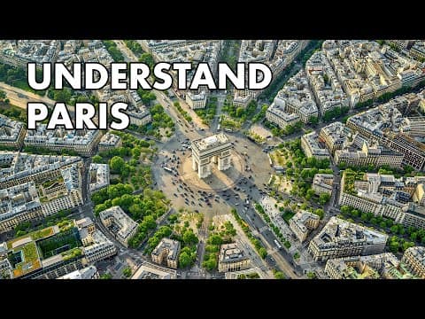
[18:09]The Arc de Triomphe, set in the center of the Place de l'Étoile, was originally proposed by Napoleon Bonaparte in 1806 after his victory in Austerlitz. In ancient Rome, triumphal arches were built for the emperor to pass through when he had won a battle.
[18:30]So again, European monarchs like Napoleon, viewing themselves as Roman emperors. Caesar Augustus, the first Roman emperor, boasted that he left in marble the city that he received in brick. Referencing the fact that he tore down so many brick buildings in Rome and rebuilt them in marble. And in 1842, Napoleon Bonaparte's nephew, Napoleon III, wrote, “I want to be a second Augustus, because Augustus made Rome a city of marble.” And from 1850 to 1870, he rebuilt much of Paris and gave the city its present appearance. When you visit Paris, you'll notice that most buildings are beautiful. Built with a classical Roman style, and they have a very special character. They're all built with a local stone known as Lutetian limestone. So you can see that Lutetian limestone has a sort of a beige tone, which gives the city a specific special character. And also has a similar tone to that travertine that the Romans used in Italy. So there's also a connection with ancient Rome right there. Napoleon III, with the help of his prefect, Baron Haussmann, made a new plan of the city where he opened dozens of wide long avenues that connected important parts of the city. This plan of primary straight avenues mirrored the street system in Rome, created 300 years earlier by Pope Sixtus V. But on a much grander scale. Their ambition was to make Paris not only the loveliest city which ever had existed, but also the loveliest that could exist. This plan integrates a few more important sites. The Hôtel des Invalides, a residence for the aged and disabled soldiers whose chapel is now a shrine for some of France's leading military figures. Most notably, the tomb of Napoleon Bonaparte. The Champ de Mars, which was used as marching grounds by the French military, and eventually became the site for the Eiffel Tower in 1889. When it was built as the centerpiece of a universal exposition that commemorated the 100th anniversary of the French Revolution. Other buildings of the Expo were dismantled, but they preserved the Eiffel Tower. Napoleon III's plan also incorporated the Pantheon on the hill of Sainte-Geneviève. Where the most illustrious people of France's history are buried.
[21:14]Two more walls were built around Paris in the 18th and 19th centuries. But both of them were ultimately replaced with Boulevards. Today, all modern buildings and skyscrapers in Paris are concentrated at the end of the Champs-Élysées axis. In an area called La Défense, away from the historic nucleus. So as you can see, urban design can take decades or even centuries to get a plan into completion. This part of Paris started with a palace and gardens of Catarina de Medici in the 1500s and developed for over 250 years to its present form. By respecting the inheritance of the past and by contributing towards the eventual realization of one of the most magnificently organized urban achievements in history, its intersection, the Place de la Concorde.


