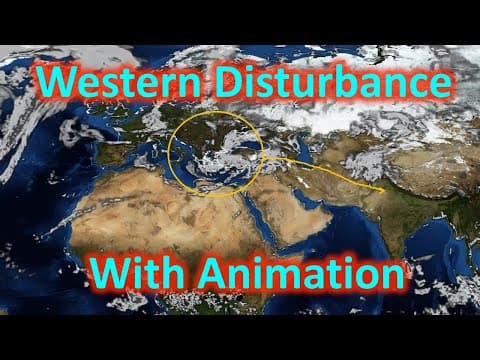
[0:09]Hello friends, Zeta axis me apka swagat hai aur aaj hum discuss karenge western disturbance. Hamare desh mein jo rainfall hota hai, vo kai tareeke se hota hai. Inki kai prakriyein hain, jismein se ek hai western disturbance, dusra hai pre-monsoon rainfall, teesra monsoon rainfall, aur chautha retreating monsoon rainfall. Is video mein hum western disturbance discuss karenge aur baki ke hum aane wale lectures mein discuss karenge, jiska link apko description mein mil jayega. To western disturbance jo hota hai, vo ek extra tropical cyclone hai, jo Mediterranean region pe develop hota hai, aur jet streams ke dwara India ki or laya jata hai. Agar hum naam ko dekhein western disturbance, to hum dekh sakte hain ki Western ka matlab hai, something jo western direction se ata hai. Ab kyunki ye Mediterranean region mein develop hota hai aur jet stream ise le aate hain, to hamare liye ye western direction se ata hai, isliye hum word use karte hain Western. Disturbance ka matlab hota hai ki koi bhi aisa region jahan pe beech mein low pressure ho aur uske charon taraf hawain is tarah rotate ho rahi hon, Northern Hemisphere mein anticlockwise aur Southern Hemisphere mein clockwise. Abhi jo disturbance hota hai, ye cyclone nahi hota hai, balki ye aisa region hota hai ya aisa condition hota hai, jo cyclone mein develop hota hai ya ho sakta hai. Normally disturbance ka matlab tropical aur extra-tropical cyclone dono hota hai, lekin yahan pe western disturbance mein, disturbance ka matlab hai extra-tropical cyclones, kyunki western disturbance keval extra-tropical cyclones hi hote hain. Is video mein hame yahan pe hawa ka bahav dikh raha hai jo hamare earth pe hota hai. Hum dekh sakte hain ki kaise ye jet streams jo hain, polar jet stream aur tropical jet stream, ye move hoti hain. Kaise inmein thoda bahut deformation hota hai. Similarly ye green color se humara ITCZ hai, kaise different seasons mein different tareeke se move hota hai. Halanki ye bhi ek approximation hai, ye exact movement nahi dikha raha hai, but ye apko ek achhi khasi understanding de dega ki kaise ye sari cheezein jo hoti hain, dynamically move hoti hain. Ab agar hum winter season ko dekhein, to winter season mein kya hota hai ki sun jo hota hai, vo Tropic of Capricorn ke upar hota hai. Aur humara ITCZ jahan pe dono hemisphere ki hawain milti hain, vo bhi Tropic of Capricorn ke kafi paas hota hai. Yaani ki ye Southern Hemisphere mein. Ye hamara tropical region hai, jahan pe garam hawain hoti hain kyunki yahan pe jo hota hai, heating jo hoti hai, vo sunlight se hoti hai. Yahan pe sun ke rays almost directly reach karte hain. Aur ye temperate region hai aur yahan pe sun ke rays jo hai, vo bahut hi slant hote hain. Isliye yahan pe thandi hawain hoti hain. Aur ye jo hai, ye border hota hai, yahan pe garam hawain aur thandi hawain ka front banta hai. Aur isi frontal activity ke karan yahan pe bahut sare cyclones generate hote hain. Yahan pe aap dekh sakte hain ki ek extra-tropical cyclone hai, jo Mediterranean region ke upar develop hua hua hai. Ab ye extra-tropical cyclone is jet stream ke dwara, jo ki Mediterranean region se hota hua hamare Indian subcontinent pe ata hai, ye is extra-tropical cyclone ko humari or dhakelta hai ya kheench ke le ata hai. Aur iske karan humein pure Indian subcontinent mein, right from Punjab to Bangladesh humein iska effect dikhta hai. Aap yahan pe dekh sakte hain ki ye pura region pe iska effect hota hai. Ab kabhi-kabhi ye jo jet streams hain, inka orientation thoda southern direction mein bhi ho sakta hai. Is samay jet extra-tropical cyclone aayega vo humare Gujarat aur Rajasthan ko bhi effect karta hai. To is tarah aap dekh sakte hain ki jo extra-tropical cyclone hota hai, almost pure Northern India ko hi effect karta hai. Is video mein aap dekhenge ki yahan pe ek extra-tropical cyclone generate ho raha hai. Ye extra-tropical cyclone yahan pe generate hone ke baad, dheere-dheere vo India ki taraf move hota hai, jo ki jet stream ke through laya jata hai. Aur fir aap dekhenge unka effect yahan pe. Yahan pe aap dekhenge ki baadal ikattha ho rahe hain, idhar bhi ho rahe hain, to pure ke pure hamare jo northern part hain, wahan pe apko baadlon ka effect dikhta hai, jo extra-tropical cyclone ke yahan pe kheenche hue aane se paida hota hai.
[4:28]To ek season mein, yaani ki ek western disturbance ke season mein jo ki December se February tak hota hai, uske beech mein hamein kareeb paanch-chhe extra-tropical ke cyclones aa jate hain. To ye basically ek cycle nahi hota hai, ismein bahut sare extra-tropical cyclones aate hain. Ye humara Delhi ka annual rainfall hai jo month-wise dikhata hai ki kaise rainfall hota hai. Yahan pe aap dekhiyega ki January aur February aur December mein rainfall jo hai, vo thoda sa zyada badh jata hai, compared to November aur March ke. To ye basically Western Disturbance ka effect hai. Similarly agar aap Lucknow ko dekhenge, to yahan pe bhi January aur February mein thoda sa zyada rainfall ho raha hai. Aap dekh rahe hain ye curve kaise niche ki or ja raha hai aur yahan pe kaise ye curve upar ki or ja raha hai. To December se leke February ke beech mein Western Disturbance jo hain, vo aate hain aur unke karan baarish hoti hai. Ye baarish pure North India mein hoti hai, right from Punjab se leke Bangladesh tak. Aur inse hamare rabi ke crops ko bahut fayda bhi hota hai. Jo wheat hum ugathe hain thandi ke mausam mein, usmein isse bahut fayda hota hai. Ab hum jante hain ki hamara jo ye Western Disturbance hai, vo ek extra-tropical cyclone hai. To extra-tropical cyclone ke aage wale hisse mein hamesha warm front hota hai. Aur hum jante hain ki warm front mein kareeb saikron kilometer tak clouds formation hote hain. Ye bahut zyada baarish to nahi dete hain, lekin ye halki baarish dete hain aur inka region bahut zyada hota hai. Isliye jab extra-tropical cyclone ata hai, to humein cloudy sky milta hai. Aur humara higher night temperature hota hai, kyunki cloudy sky hone ke karan jo humara Earth hai, vo heat jaldi lose nahi kar pata hai, isliye garmi thodi si badh jati hai. Moreover extra-tropical cyclone mein beech mein warm air trapped hota hai. To iske karan bhi humara night ka jo temperature hai, wo halka sa badh jata hai. Barish to hoti hai kyunki yahan pe itne sare clouds hote hain, jo extra-tropical cyclone mein aate hain, to unke karan baarish hoti hai. Ab kyunki ye baarish humari thandi ke mausam mein hoti hai, uske karan humara temperature aur kam ho jata hai. Isiliye cold wave ata hai. Aur kyunki thandi badh jati hai, iske karan hamein subah-subah fogs bhi dekhne ko milte hain across the Northern India. Agar ye Western Disturbance mein baarish bahut zyada ho jaye, to iske karan hamare jo rabi ke crops hote hain, vo damage ho jate hain. Floods bhi aate hain kai jagah. Humare Ladakh ke floods bhi isi Western Disturbance ke karan aaye the, 2009 ya 2010 mein. Aur kuch log kehte hain ki jo Uttarakhand ka jo flash flood tha, wo bhi Western Disturbance ke karan hi trigger hua tha. Western disturbance jab thande pradesho mein jata hai to uske karan wahan pe snowfall hota hai, bahut heavy snowfall hota hai aur jiske karan avalanches bhi aate hain. To aap dekh sakte hain ki excessive baarish hone ke karan ya excessive precipitation hone ke karan kai jagah flash floods, avalanches ya crop damages bhi ho sakte hain. To kuch mamlon mein Western Disturbance achha hai jaise vo rabi crops ke liye pani deta hai, lekin agar excessive baarish hone lage to uske karan nuksan bhi zyada hi hote hain. Umeed karte hain apko Western Disturbance ka humara ye video achha laga hoga aur aap hamare video ko like aur subscribe zaroor karenge. Agar achha laga ho to please apne dosto ke sath share bhi karein. Thank you.


