[0:00]Welcome. I wanted to show these three maps today. Um, one is from 1595. This one here is from 1606. Let's see, this one is the 1595 and this one is also 1606. So I want to focus on a few different points. Um, first of all, an interesting point here is we have Greenland with no ice. And that's pretty interesting to have charted mountains and rivers and even right here, we can see some towns. One town, two towns, that's how they mark their towns as you can see in Iceland here, which is spelled island at the time. Many towns and totally ice-free. And again, this would be 1606. And yeah, you you get an idea of what the towns look like, what the forest look like. And what I wanted to focus on was this little island here called it appears as if it's called Freeland here, but at times it's called Friesland. Or like Friesland maybe. And you can see how many towns actually there are in Friesland. I mean, it this is not some imaginary town. Now, if we jump over here, we also see Friesland with many towns. Iceland, still many towns, Greenland free of ice. And if we jump over to this map from 1606, we can see it here. Friesland. And here it has the S. This map shows up really crisp. So here we have Greenland, Gronland. Iceland again, spelled with I-S-L-A-N-D.
[2:39]And here it is again. Now, if we jump over to this map, a modern-day map, which of course is a little exaggerated, but there is no sign whatsoever of Friesland. I mean, like none, not even close. And I'm just going to focus on three maps today, but hundreds in verify this.
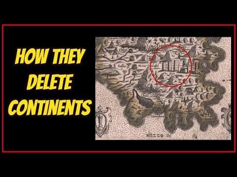
[3:15]Now, the next thing I wanted to focus on was these towns in Asia. Or what we call Asia in modern times. Now, Asia would be up here, and over here we would have Europe, and Sweden and Finland and right here, we have Russia. And in in these times, Russia was called Rus. And this is shortly after the name was Tartaria. So already we see Tartaria replaced with Rus. But what I was going to focus on was these parts of Asia, which we would now call Mongolia. And just to have a reference, let's see what it looks like on this map.
[4:22]So, yeah, we're going to be talking about this area, upper Siberia. No, not Mongolia. I was totally wrong, sorry. So, yeah, this is just Siberia. And very remote. I mean, you know, Moscow is over here by Europe, and most of the towns are in this lower area. And I mean, when you're talking this is like equivalent to, you know, our Alaska, but much bigger and much more. And so, yeah, let's have a look on the old map now of this region. And we see many towns amongst these mountains.
[5:07]Here, and here a bigger one that appears to be a castle. Smaller, but still substantial and and even something here, I'm not sure what that is. It's coming in a little grainy for me. And here we have Tartar Wild. These are the Tartar Cities. Now, let's jump over to the very same maker. By the way, this is Mercator. Again, this map of Mercator is very, very similar, also of 1595. But what we can see sorry, I was having an issue. Now what we can see is in this northern part of Asia, we have one and two towns in this region where we had about half a dozen before. We still see this strange thing. I don't know if it's a figure of a man or a statue. But now he has no color. And yeah, much less activity. Much less activity as we saw in this earlier version.
[6:37]You see Friesland. Mercator always felt it was important to put Friesland in his maps. I mean, you know, you you're pretty limited here. He has he has four spots. And Friesland is zoomed in, whereas typically it is here. You can see, it's a very it's not even very small. It's a it's a fair size island. It's about a half of Iceland. So, yeah, again, here it is now in this later version of of 1595 map. And really again, this is all about an 11-year change. From 1595 to 1606. And here, we now see nothing. We see ghosts. Ghostly shells of towns, but not significant, not like we see in these maps. When we look at Friesland or in this one. Very significant. Very significant town activity. It's it's very clear and he puts this in the corner of his map and then we see this. And there may be one here or or maybe but really they've become ghosts. And so, next, I want to focus on this very most obvious part of this map of 15 95, which is this. I mean, this is absolutely amazing. This North Polar region. And again, Mercator, Mercator gave us this map. I mean, maybe not this exact version, but when we started using this map, this is Mercator who gave us this. And he's a very respected mapmaker. And we can assume that he was a fool and and put this island here with great detail. And here in the center is Rupus Nigra, is what he calls it.
[9:16]And this is the North Pole. This is a magnetic black rock, as it's been described in the text that we do have. I mean, there's a lot of a lot written about this and obviously there's mapmaking. And we can see this in hundreds, if not thousands of maps. Even in this map, we see it. We see it in this version. And this map maker's name was Polus Marula. And this island appears to be gone now. Just a little tip shows up on maps these days or Google Earth. This Nova Zemla. Just a little piece of it. It even has that name still. But definitely this North Pole is gone. And yet up to a certain date, we always had this. And here if you look to the left, we have Greenland. And Greenland almost connects in most maps. And then we would have Iceland right here. And in this map, we cannot see Friesland. And it would be off right about here. So this North Pole. Here we see, we have Pygmies, a region inhabited by Pygmies. Now, this I think is written in Latin. Um, And these rivers, and as it's been written, and again, I don't have the writings here, but I've I've heard, there's a lot of a lot of information. And these rivers were said to flow inward. I think one, maybe one or two float outward and one float inward, but it was as if it was a drain and sailors would get pulled in, and it was very difficult to get out. And really fascinating. And only 11 years later, we now see a portion of this pygmy portion missing. It's missing, it's been faded out, and these islands have changed right here, which pretty much, you know, you might be able to, or regardless, here's the Nova Zemla that I was talking about. And, yeah, these islands have completely changed. They've been redrawn and and pretty much some things are just gone, some some parts of it are completely gone. And so, the next thing that I wanted to focus on was something on this map actually. And I'd like to do another video more on on the Americas. North America. But, I found this really fascinating how right by where Chicago might be, we have Chilaga. And we have a town, again, we see a town on the river and in all maps, this is this region here is always Chilaga. And to me, it always seemed like it was very much like Chicago. But here again, you can see the North Pole in this map as well. And Iceland is called Island. And we can see it here. Iceland and Greenland. And here I believe we can see Friesland. So Friesland is still here. And even another island that's pretty much close to the east coast of Canada. And, you know, I encourage you to pull these videos up and study them for yourselves. I mean, they're really, really fascinating. And especially these areas where, you know, if you look on Google now, you know, I mean, what are you going to get when you look at Greenland? Here's what you're going to get. And I don't really think, I don't really think this we're seeing what we're seeing. I think this is just kind of imposed over. I mean, this doesn't look. And I've played around with Antarctica and you'll see pure ice. And then if you zoom in and allow it to load a little bit, and it's doing it a little bit here, things will load. And I've actually pulled up lakes and green mountains in Antarctica. And I've done the same thing with the deserts in Nevada, where it looks like just a bleak white kind of tan desert, and then you zoom in, and there's all sorts of amazing things. But, yeah, I find it fascinating that, you know, these older maps completely show all the rivers and, I mean, we get a better picture of what's really going on from these older maps than we do from from these Google images, that's for sure. I mean, here we can see Iceland. Now, let's note on this map. How this little town right here called Saxa next to Skull Bolden. Beautiful castle of Skull Bolden. Has three what look like towers. Three skyscrapers. And if we jump over to this version, down here, we again see these three skyscrapers. Two mid-size and one larger than the others, and this Skullholden Castle. Now, I find it really interesting that if we look at where the ice is, it appears to me as if the ice is sitting right on top of this area.
[15:42]And once again, let's have a look right where that would be. Boom.
[15:53]But again, giant chunks of of missing. I mean, when we looked at those older maps, there were towns all over Iceland, and it was completely ice-free. And that's not what we see now. And we certainly don't see our little island of Friesland, which was half the size of Iceland in thousands of maps going back as far back as mapmaking goes. And I find it really fascinating. And of course, our North Polar region is completely missing. And I don't know. I mean, I think what are we really looking at here? I mean, what has what has Google given us? But I find it interesting that there is no imagery here. But yet if you go over here, there's a little trick that I've seen. I saw it on YouTube and you can go to this little island here pretty much in between, Alaska and that Siberian region. You just zoom into this little island here and all of a sudden, it's like, I don't know if someone was leaving us this as a little clue. But this thing goes on and on. And I think it goes right to the North Pole. And I followed it and I don't know. I don't know if I'll do it too much of it right now. And you can go back and do this yourself. But yes, I mean, I think that, you know, and I don't know how much we could we can really zoom in.
[18:05]But, yeah, there's activity here. There's action, as there has been shown in all of these older maps. So it's pretty fun actually. I'd encourage you to go take a little trip down this line here, and it's very much full of of more truth than I think what we see here. So, that's it for today. Thanks so much for watching. Please like, subscribe, and comment. Have a blessed day.


